
REPRINTS
The Hockanum River has played many roles throughout our town�s history � some stories are imbued with pristine nature and
some with smelly pollution.
Today, the Hockanum is known as a place for recreation and canoe races. The river originates at Shenipsit Lake, and
flows into the northeast part of Manchester, and then out west to East Hartford, eventually joining the Connecticut River.
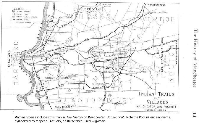
Before written history, Native Americans camped and fished along the Hockanum and its tributaries. �Hockanum� comes
from the Native American word Hocquaun, meaning hook-shaped or crooked river. In their 1923 History of Manchester,
Connecticut, authors Mathias Spiess and Percy Bidwell describe the Podunks, the tribe whose homeland is in the area east of
the Connecticut River, in current East Hartford, South Windsor, and Manchester. Spiess includes a map of trails and
encampments (see photo from the book), one of which is in the area of Verplanck School, where there is a handy blue metal
sign, installed in 1976, telling about the camp.
The Podunks
Mathias Spiess took a great interest in the history of the Podunks, and suggested 80+ years ago that archeological digs be
conducted in areas of known camps. Mr. Spiess personally owned hundreds of artifacts, which he donated to the Town.
As far as I know, archeological digs didn�t happen at the former Podunk camps, but digs have unearthed centuries-old
Native artifacts throughout New England.
This goes to show that history can be �new,� in that we refine and authenticate our previous impressions of the past.
Scientific techniques and a new interest in the Native roots of our land have brought a greater understanding of the
life-ways of Native people, of their religion and their concept of property. We have new perspectives on former treatment
of Native peoples, including suppression of language and culture. In 1990, the Native American Graves Protection and
Repatriation Act provided, among other things, for interment of human remains that had previously been dug up and displayed
at museums. Today, we take for granted the protection of burial grounds and sites sacred to native peoples, but that was not
always the case.
A Digression
I recently had two opportunities to learn more about Native Americans. In April, my husband and I visited the
Mashantucket Pequot Museum, an amazing experience. We saw displays of the post-Ice Age geological changes that made our
land more hospitable to humans. We watched oral-history interviews on film, took an audio-guided tour of a Pequot village,
and learned how wigwams are built.
In elementary school, when we last studied Native Americans, I sure didn�t know that aboriginal people came here 12,000
years ago. My impression as a youngster was that they were here a few hundred years before Columbus, and that their history
centered on wars and battles, which mostly happened out West.
The other opportunity was an Elderhostel: Deerfield (Massachusetts) Through the Centuries, which included lectures and
a slide-show about the Pocumtuck people, and the geology of the Deerfield and Connecticut river valleys, which encompassed
the Pocumtuck homeland, and which the English settled in 1669. Recent archeological digs have unearthed artifacts from
earlier centuries, and Deerfield now honors and interprets its Native American past, as well as the Deerfield colonial and
post-Revolutionary War village. Visitors of Native American ancestry still come to visit Deerfield.
But, getting back to the Hockanum River: In the 1600s, settlers built sawmills along the river to cut lumber from the trees
they felled for constructing houses. There were sawmills and gristmills along streams throughout New England from the time
of European contact. The rivers ran swiftly enough to turn a millwheel, for direct water-power.
During this period, there were conflicts between the Podunks and other regional tribes, such as the Mohegans, as well
as between the European colonists and the Podunks. The Native Americans used the land differently from Europeans, and had
a different concept of property �ownership,� a concept that wasn�t understood at the time, and certainly wasn�t well
expressed in those old history books we read as kids.
By the late 1700s, as the Industrial Revolution brought more sophisticated use of water power, dams and raceways were
built along the Hockanum, with villages growing up around the mills.
Oakland Mills
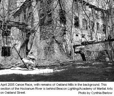
In the northern section of what would become Manchester in 1823, there was Oakland, a village that housed workers at
the Oakland mills. Remains of the brick mills still sit right next to the Hockanum River along Oakland Street (Route 83) at
the junction of Tolland Turnpike. From the road, the mills look mysterious and romantic, although they have probably
deteriorated beyond repair.
These paper mills were established in 1784 by Butler and Hudson, and operated under various owners and through various
reorganizations, manufacturing high-quality papers, including bank-note paper and all the post-card paper for the U.S.
government.
In 1899, the American Writing Paper Company, an early conglomerate, bought the Oakland Mill, and replaced former wooden
buildings with brick.
Like many businesses, the paper mills suffered financially during the Depression, and went out of business in 1933.
Dexter Company bought the mills and processed pulp there for a while. Other businesses have used the buildings since then,
including Raybestos, Conyers (cement casting), and a recycling center.
Union Mills
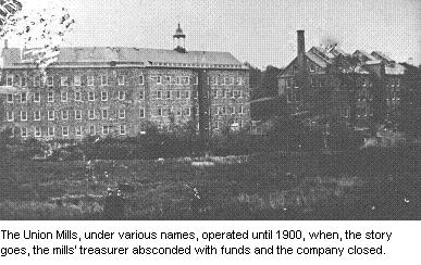
In 1794, a group headed by Samuel Pitkin established a cotton mill along the Hockanum, just west of today�s Union
Street. David Watkinson and his brothers took over in 1819, and renamed it the Union Manufacturing Company.
In 1866, the company built the Union Dam, 20 feet thick at the base. It was the only dam in Manchester that survived
the violent flood of October 1869. Union Manufacturing, as other employers of the time, built housing for workers � many of
these houses still exist in the �Old North End.�
Cheney Brothers bought the buildings and water rights, and built an electric generating plant in 1901 on North Main
Street next to the river. Huge metal pipes brought water from Union Pond to the power-generating plant, and wires on
electrical poles brought the power to the south end of town for the silk mills. Stones from the Union Mills were re-used
in building Cheney Mills, but no buildings remain at the site of the former cotton mill. Union Village, however, was
designated a National Historic District in 2002.
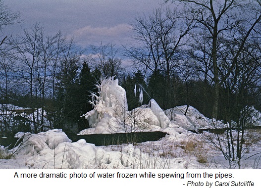

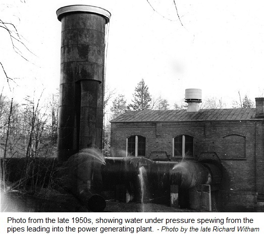
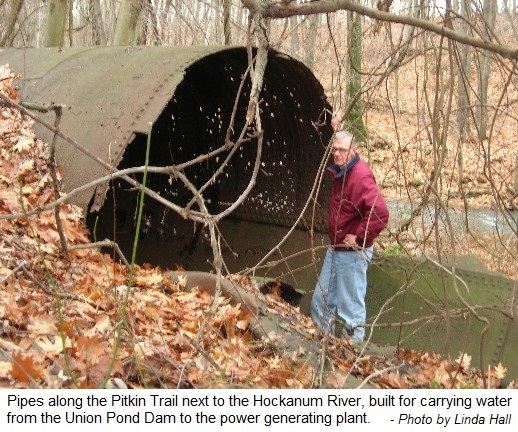
The pictures at right show the standpipe at the power generating plant, and the pipes which brought the water from Union
Pond to it. In the 1950s the pipes fell into disuse and disrepair and sprung leaks, which in the winter would freeze.
Click each image to bring up a larger version of it.
Ledyard & Watson Mill
Near this power plant, where North Main Street crosses over the Hockanum, is the site of the Ledyard and Watson paper mill,
which furnished paper to The Courant on which the report of Lexington and Concord battles was printed in 1775. Although the
mills are gone, this scenic section of town has several handsome old houses.
Other Mills Along the River
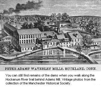
Have you eaten at the Adams Mill Restaurant? Then you have visited a former
paper mill, owned variously by Champion, Debit, Goodwin, and Pickles. Mills at this location date back to the late 1700s.
Peter Adams bought the mills in 1864, and then others operated businesses there, including Standard Washer and Mat in the
fairly recent past. The building that houses the restaurant dates to 1880, and was the last structure built in the
paper-mill complex.
The Hilliard Mills, large woolen mills, were the center of Hilliardville,
and although Bigelow Brook was their first source of water power, they also made use of hydro-electric power created by
damming the Hockanum between Adams Mill and Hilliard Street. The mill properties are currently undergoing restoration
aiming towards multiple-tenant usage.
Laurel Marsh, created by a dam in East Hartford, was originally a pond for mills at Burnside. Later this area
became a Trolley Park, closing in the early 1920s.
Pollution
By the early 1900s, mills had begun to use other power sources besides the Hockanum River. But they continued to use
the river for disposing of waste, such as solid fibers and dyes from paper-making and fabric production. The brooks flowed
in different colors, and children were warned not to go near the water. Industrial effluent created unpleasant smells and
killed off fish.
The revival of Connecticut�s waterways took a major change in our attitude toward the environment as well as the
Connecticut Water Pollution Control Act of 1967, a model for the subsequent Federal Clean Water Act.
Through legislation, town and volunteer efforts, community organizations, and even the National Guard, the river began
to get cleaned up.
Hockanum River Linear Park Committee (HRLPC)
The HRLPC began in 1970, a joint effort of the Conservation Commission, the City Beautiful Committee of the Chamber of
Commerce, and the Manchester Jaycees. Its chairman, Doug Smith, leads work parties three days a week to maintain 15 miles
of blazed trails along much the Hockanum�s 5.8 miles in Manchester. In addition to hikers, the river and watershed
accommodate kayakers, canoeists, and cross-country skiers. For more information about recreation and about the committee,
see www.hockanumriverwa.org. The Manchester Historical Society salutes the HRLPC
for over 39 years of preserving Manchester�s natural beauty and charm.
As we enjoy the Hockanum trails, we can try to imagine the days of the Podunk people and other Native Americans, who first fished and hunted along the Hockanum River and who lived on this land we now call Manchester.


All content copyright 2025, Manchester Historical Society, founded 1965. All rights reserved.